|

|
|
| Product Information: | ||
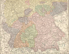
| Details: | 1896 Map of Western Germany; 1 pp; Map; Published: 1898; 10.5x14; Item # FS031 This is a full color reproduction of a map of Western Germany from Rand, McNally & Co’s Universal Atlas of the World, Containing Colored Maps of Every Country & Civil Division Upon the Face of the Globe with marginal index together with historical, descriptive, and statistical matter pertaining to each, ready reference lists to the United States, colored statistical diagrams, and city maps, also a concise review, richly illustrated by engravings, of the world's peoples … Areas included here are Wurtenberg, Baden, Prussia, Hessen, Bavaria, Saxony and many more smaller areas! All of these maps come in a protective, archival safe sleeve. |
|